Tour of the Canyons Part 1: Bryce!

1C2E58DC-DE03-4956-9909-4EC72F7F1939The AIR Adventures team is on the road again this summer, for our annual tour of national and state parks! This time, the theme is canyons, as we’ll be visiting the corners of Utah and Arizona where some of our country’s most popular canyon parks, including Bryce, Zion, and of course, the Big Ditch (aka Grand Canyon). Taken together, these three parks make up part of the Grand Staircase – a vast region made up of different plateaus canvassing millions of acres across Colorado, Utah, and Arizona.

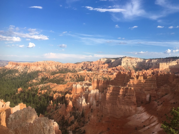
Our first stop was the uppermost ‘top’ step of the staircase in Southwest Utah, where Bryce Canyon is located. The park is by no means the largest – spanning just over 35,000 acres – but it certainly packs a strong visual punch in that circumscribed space. Specifically, Bryce is known for its ‘hoodoos’ – rock formations that have been shaped and twisted by erosion over time into fantastical and bizarre sculptures (insert some overused wordplay joke about ‘Hoodoo – you do, she do, we do!’ here). Bryce Canyon boasts the largest collection of hoodoos in the world.

We opted to explore this strange landscape on foot, as Bryce has over 65 miles of trails winding throughout. Our first run took us on a loop around ‘Fairyland,’ where the trail started us on a series of switchbacks that zigged and zagged over a mile down into the Bryce amphitheater, before turning into a rollercoaster of twists and turns that wound its way through some of the most eye-popping collection of wind- and sand-chiseled rocks in all manner of strange shapes and sizes. It was easy to see how this section of the park earned its name, as we could easily imagine the rocks to be some petrified remnants of magical flora and fauna. All-in-all, the run totalled about 8 miles from Sunrise Point, with just over 1600 feet of elevation gain. Check out our route here!

Adventures in Fairyland.

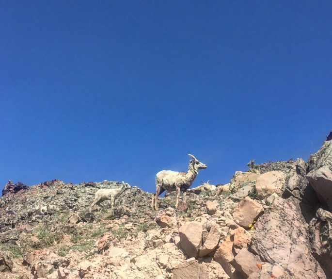
The next day, we ventured out into the less popular – but equally impressive – wilderness of Bryce Canyon. While most of the park’s 2 million+ annual visitors stick to the hoodoo viewpoints, fewer take the opportunity to explore the backcountry of the park. However, it’s on the less-traveled wilderness trails where one can truly appreciate the ecological splendor and value of Bryce. With the altitude of the park ranging some 2000 feet, it encompasses three distinct climate zones, each home to a wide array of plant and animal life – including mountain lions, pronghorn, and the endangered Utah prairie dog. Our trek into the backcountry took us on an out-and-back route along the Rim Trail from Sunset Point to Bryce Point, where we then took the Under the Rim Trail that descended over 2,000 feet down into the valley floor to Yellow Creek. While we’d originally planned a point-to-point rout that would end at the Whiteman Bench, at Yellow Creek the trail became difficult to find and we opted to play it safe and return the way we came. All-in-all, this route took us nearly 14 miles, with some 2500 feet of elevation gain – all on the return trek, of course! Check out our route here!

Throughout our stay, we also opted for a few shorter, 1-3 mile hikes that also afforded beautiful – and more easily accessible – views. These included the popular hike through the Queen’s Garden, as well as the Bristlecone Loop bear Rainbow Point – one of the highest points in the park.

Interested in going? Definitely take a moment to check out the park’s website and plan your hiking or running routes here. Be aware that especially when hiking the backcountry, the trail conditions and signage are variable, and (as we discovered) the trail may not be as well-maintained as it is near the hoodoos and in the more popular areas of the park. We definitely recommend downloading a GPS map that allows you to track your location, to avoid getting lost in the backcountry. Just as important: be aware that during the summer months, it gets *hot* – and quick! Start your hikes or runs early in the day, and bring plenty of water to avoid dehydration.


Taking in a composition in red: Arches NP

From the high mountain wilderness of northern Wyoming and Montana we continued our journey south, to explore the desert canyons and mesas of Utah.

Since our visit to the Grand Canyon on our cross country trip two years ago, we’ve always wanted to revisit and spend a bit more time in this region – specifically the renowned ‘Grand Circle’ of national parks that includes Grand Canyon, Capitol Reef, Bryce Canyon, Arches, and Zion.

With limited time, we focused our trip on these latter two parks, with Arches NP being our first stop.

Located just outside Moab in southwest Utah, Arches is an ethereal composition in vibrant red sandstone of grandiose towers, impossibly balanced rocks, and the world’s largest concentration of natural arches. (It’s also by far the most phallic of the national parks. I mean just look at the cover photo).

With only a day to explore the park’s 76,519 acres, we decided the best way to do so would be by bike. We started out at the trailhead of a multi-use path just south of Moab, which took us straight to the park entrance. From here, the road kicked up and climbed a little over 1,000 feet – up to a vista point that afforded panoramic views of many of the giant phalluses amazing rock formations for which the park is famed.

FullSizeRender
Balanced Rock. 3,600 tons of sandstone that could topple at any moment, but for now is standing strong for your Instagramming pleasure.

The road that winds through Arches is essentially an out-and-back route totaling a little over 45 miles. Along the way there are many offshoots that take you past the more well-known arches and formations, including Balanced Rock, the Windows, and Delicate Arch – to name a few.

ArchesNP bike
Arches NP by bike. Super hot fun in the desert sun. 

As the day heated up quickly, we did our best to conserve our energy and not go *too* hard on the bike. Of course, there may have been one or two occasions where we picked up the pace to have a bit of fun – and *maybe* took a couple of Strava CRs and QOMs in the process. 🙂

Check out our route here!

Interested in going? Check out the Arches NP website here, with info to help plan your visit. If you’re intending to do a longer bike ride like we did – or spend any extended amount of time there on a hike, run, etc., be sure to:

1) Go early. It gets hot quickly, and the mid-afternoon heat and sun can make your day much less pleasant than it should be.

2) Take plenty of water with you (Why? See point 1 above. It’s the desert. It gets hot and stays hot). If you need to refill your water bottles, there are fountains at both the Visitor’s Center as well as Devil’s Garden (the turn-around point of the out-and-back route).

Fee? Yes – $25. Pets? Yes – but not on trails. Bikes? Yes – on the road.

Stay tuned for our next adventures! We hope your summer was equally adventurous, exploring new trails and beautiful parks. Tell us all about it in the comments below!


Yellowstone: Because what could be more epic than a park on top of a supervolcano.

Following our visit to Craters of the Moon in Idaho, we turned to the northeast, making our way towards the wilderness and famed national parks of northern Wyoming. Our first stop was none other than the flagship park of the National Park Service: the iconic Yellowstone.

Apart from its distinction as the first national park, Yellowstone is also a geologist nerd’s delight: It’s essentially 2.2 million acres atop an ancient supervolcano. Everything in the park – from the rivers and lakes, to the flora and fauna – is in turn affected by the volcanic forces at work. Within the 30 by 45 mile caldera are some of the most impressive geysers and hot springs in the world, including the emblematic Old Faithful and Grand Prismatic Springs, along with lesser known (but equally awesome) features like Dragon’s Breath, Artists Paintpots, and others.

IMG_0605
Yellowstone gets its name from the colored rock surrounding the Yellowstone River, which winds its way throughout the park.

(Important note: When exploring the park’s geysers and hot springs, stick to the boardwalks. The surrounding area is not only fragile, but surrounded by boiling sulfuric acid; you will die a horrible death if you jump in. 😊 )

IMG_0604
These helpful signs found throughout the park show the impending doom that awaits if you step off the boardwalk. You will get hurt while onlookers point and laugh or walk away indifferently.

We spent a total of 4 days in Yellowstone, which we agreed was still not enough time to fully take in and appreciate this massive park. That said, we tried our best to explore as much of it as we could by foot and by bike.

One of our favorite runs/hikes took us to the summit of Mt. Washburn and back down. We started at the trailhead on Dunraven Pass, just off Grand Loop Road. From there, we climbed roughly ~1,500 feet over 3.5 miles to the summit. Along the way, we were afforded sweeping views of the surrounding meadows and countryside, awash in varying shades of lavender, rose, and yellow wildflower blooms.

Near the summit we were happily greeted by a small herd of bighorn sheep! They seemed unafraid of humans, and we did our best to give them sufficient space as we continued to make our way to the summit.

Check out our route up Mt. Washburn here!

IMG_0606
Bighorn sheep silently judging our mountain running skills near the summit of Mount Washburn.

(Another important note: Yellowstone provides a refuge to several species of wildlife; apart from bighorn sheep, it’s also home to buffalo, elk, moose, grizzly and black bears, wolves, and others. If you encounter any wild animal in the park, please be respectful of them and give them space. The park offers guidelines of 100 yards for non-carnivorous species like buffalo and elk, and 200 yards for carnivorous species like bear and wolves. Additionally, it’s a good idea to carry – and know how to use! – bear spray when running, hiking, or biking in Yellowstone or other parks in the region. While bears are not generally aggressive unless provoked, it’s best to be prepared).

The following day, we opted for a bike ride that took us on a 68 mile loop from Canyon Village clockwise to Norris, through Mammoth Hot Springs to Tower, and back up Mt. Washburn before descending back into Canyon. While the ride was challenging – with nearly 6,000 feet of climbing – it was also one of the best ways to experience the the park. We were able to see so much that we otherwise would have missed in the car – including a big bull buffalo rolling in the dust on the side of the road (!), just barely hidden by a small pine grove, or a pair of marmot chasing each other over and around fallen trees.

On our ride, we made another ascent up Mt. Washburn, this time starting from the northern side at the Tower-Roosevelt junction, and making our way up 2,300+ feet over ~10 miles to the summit. The climb offered us breathtaking (quite literally) views of the valley below that we would not have enjoyed or appreciated as much if we had been speeding by in our little Toyota.

IMG_0607
Our bike ride took us through some of the most beautiful – and less traveled – areas of Yellowstone.

Check out our bike route here! (FYI, if you opt to do this route, Mammoth offers a nice halfway(-ish) point for refilling your water bottles).

Before closing out this entry on Yellowstone, we owe a shoutout to Xanterra, the company that manages much of the lodging and dining throughout Yellowstone. They make a concerted effort to prioritize environmental stewardship in everything they do: from building their lodges with beetle-killed pine, to eliminating plastic and styrofoam from both lodging and restaurants. We mention this, because this was in marked contrast to the environmental *irresponsibility* we observed in the dining, general stores, and lodging at Grand Tetons, our next stop.

So our final tally for Yellowstone: 68 miles biked; 26 miles run/hiked; hundreds of buffalo, 10 bighorn sheep, 6 elk, 3 moose, 2 pika, 2 marmot, and 1 bear (grizzly!) sighted.

Interested in going? With ideal weather conditions, late spring and summer are the most popular times to visit Yellowstone. If you’re planning to visit during the months of April – August, be sure to book your lodging/camping reservations months ahead of time.

Fee? Yes – $30 per vehicle for a day pass; national park annual pass also accepted.

Dogs and other pets? Yes, but not on trails. MTB? Yes – on designated trails. Check signs!

Next stop: Grand Tetons!