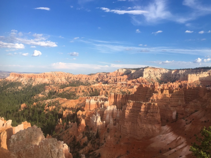
 The AIR Adventures team is on the road again this summer, for our annual tour of national and state parks! This time, the theme is canyons, as we’ll be visiting the corners of Utah and Arizona where some of our country’s most popular canyon parks, including Bryce, Zion, and of course, the Big Ditch (aka Grand Canyon). Taken together, these three parks make up part of the Grand Staircase – a vast region made up of different plateaus canvassing millions of acres across Colorado, Utah, and Arizona.
Our first stop was the uppermost ‘top’ step of the staircase in Southwest Utah, where Bryce Canyon is located. The park is by no means the largest – spanning just over 35,000 acres – but it certainly packs a strong visual punch in that circumscribed space. Specifically, Bryce is known for its ‘hoodoos’ – rock formations that have been shaped and twisted by erosion over time into fantastical and bizarre sculptures (insert some overused wordplay joke about ‘Hoodoo – you do, she do, we do!’ here). Bryce Canyon boasts the largest collection of hoodoos in the world.
We opted to explore this strange landscape on foot, as Bryce has over 65 miles of trails winding throughout. Our first run took us on a loop around ‘Fairyland,’ where the trail started us on a series of switchbacks that zigged and zagged over a mile down into the Bryce amphitheater, before turning into a rollercoaster of twists and turns that wound its way through some of the most eye-popping collection of wind- and sand-chiseled rocks in all manner of strange shapes and sizes. It was easy to see how this section of the park earned its name, as we could easily imagine the rocks to be some petrified remnants of magical flora and fauna. All-in-all, the run totalled about 8 miles from Sunrise Point, with just over 1600 feet of elevation gain. Check out our route here!
Adventures in Fairyland.
The next day, we ventured out into the less popular – but equally impressive – wilderness of Bryce Canyon. While most of the park’s 2 million+ annual visitors stick to the hoodoo viewpoints, fewer take the opportunity to explore the backcountry of the park. However, it’s on the less-traveled wilderness trails where one can truly appreciate the ecological splendor and value of Bryce. With the altitude of the park ranging some 2000 feet, it encompasses three distinct climate zones, each home to a wide array of plant and animal life – including mountain lions, pronghorn, and the endangered Utah prairie dog. Our trek into the backcountry took us on an out-and-back route along the Rim Trail from Sunset Point to Bryce Point, where we then took the Under the Rim Trail that descended over 2,000 feet down into the valley floor to Yellow Creek. While we’d originally planned a point-to-point rout that would end at the Whiteman Bench, at Yellow Creek the trail became difficult to find and we opted to play it safe and return the way we came. All-in-all, this route took us nearly 14 miles, with some 2500 feet of elevation gain – all on the return trek, of course! Check out our route here!
Throughout our stay, we also opted for a few shorter, 1-3 mile hikes that also afforded beautiful – and more easily accessible – views. These included the popular hike through the Queen’s Garden, as well as the Bristlecone Loop bear Rainbow Point – one of the highest points in the park.
Interested in going? Definitely take a moment to check out the park’s website and plan your hiking or running routes here. Be aware that especially when hiking the backcountry, the trail conditions and signage are variable, and (as we discovered) the trail may not be as well-maintained as it is near the hoodoos and in the more popular areas of the park. We definitely recommend downloading a GPS map that allows you to track your location, to avoid getting lost in the backcountry. Just as important: be aware that during the summer months, it gets *hot* – and quick! Start your hikes or runs early in the day, and bring plenty of water to avoid dehydration.